Israel says Rafah is home to Hamas’s last intact battalions, and that its war against the militants cannot be won without a decisive battle there, despite months of warnings from U.S. officials and humanitarian groups that a military operation in the southern border city would be a disaster.
President Biden cautioned Israel on May 8 that he would withhold weapons if troops were to move on “population centers” in Rafah — once home to 1.4 million people — a red line that has appeared to recede amid the chaotic mass flight of civilians. For the first time on Friday, the Israel Defense Forces said that troops were operating in “central” Rafah.
GET CAUGHT UP
Summarized stories to quickly stay informed
As Israeli troops advance and international outrage grows, the United States now says it does not want to see a “major operation” in the city. Pressed Tuesday on how Washington defines that term, National Security Council spokesman John Kirby described it as “thousands and thousands of troops moving in a maneuvered, concentrated, coordinated way against a variety of targets on the ground.”
Israel sent an additional brigade to Rafah this week and now has six operating in and around the city, according to its army-operated radio station. That’s a fighting force similar in size to the one that battled in Khan Younis, a larger southern city.
Defense Minister Yoav Gallant said last week that Israel plans to broaden its offensive in Rafah, which he characterized as a “precise” operation.
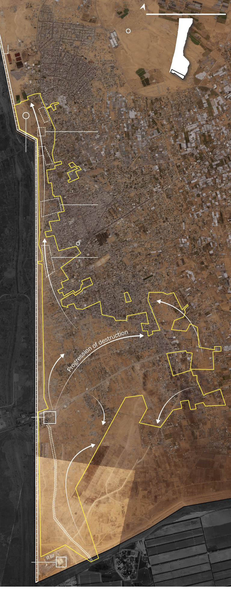
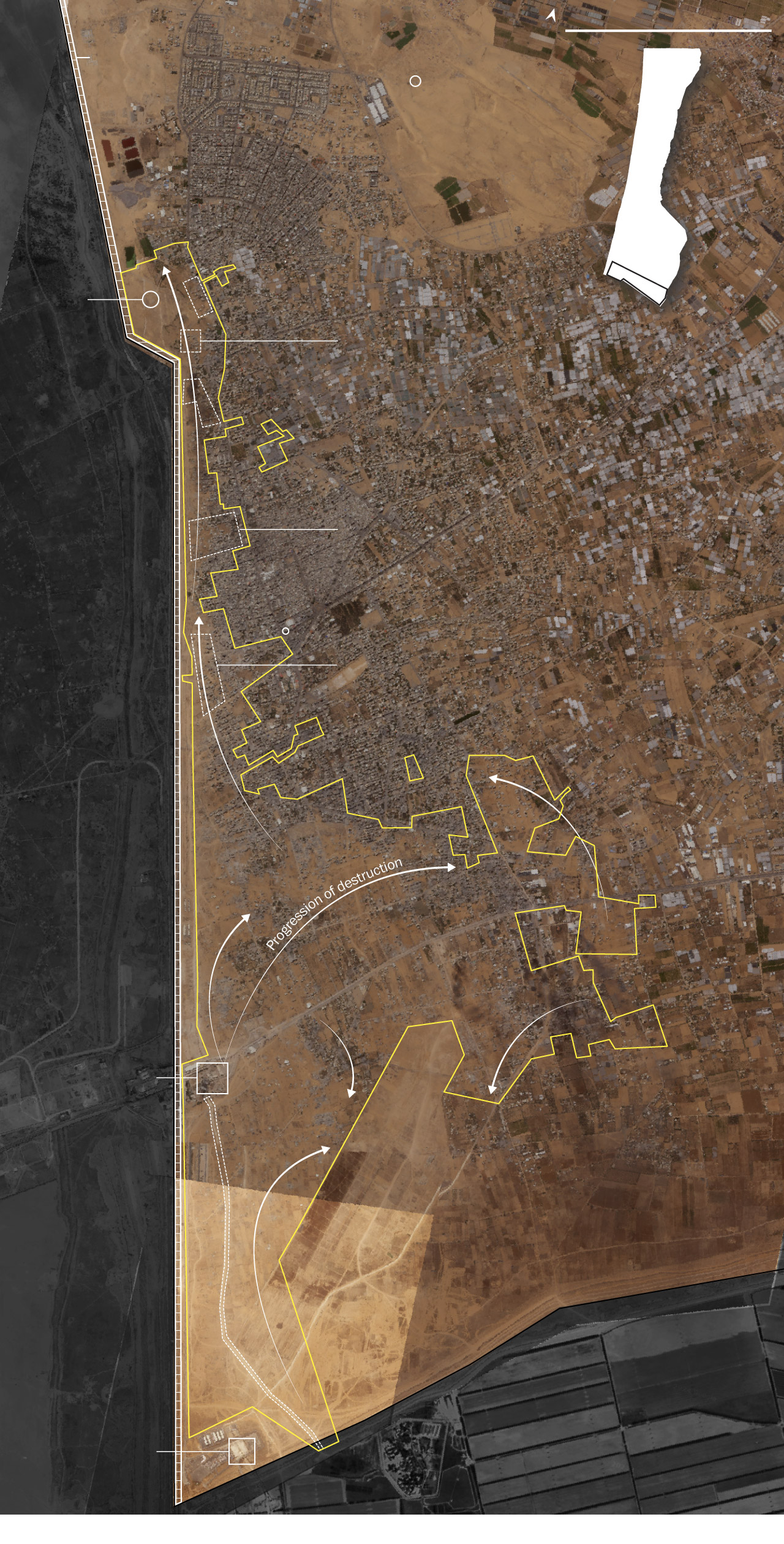
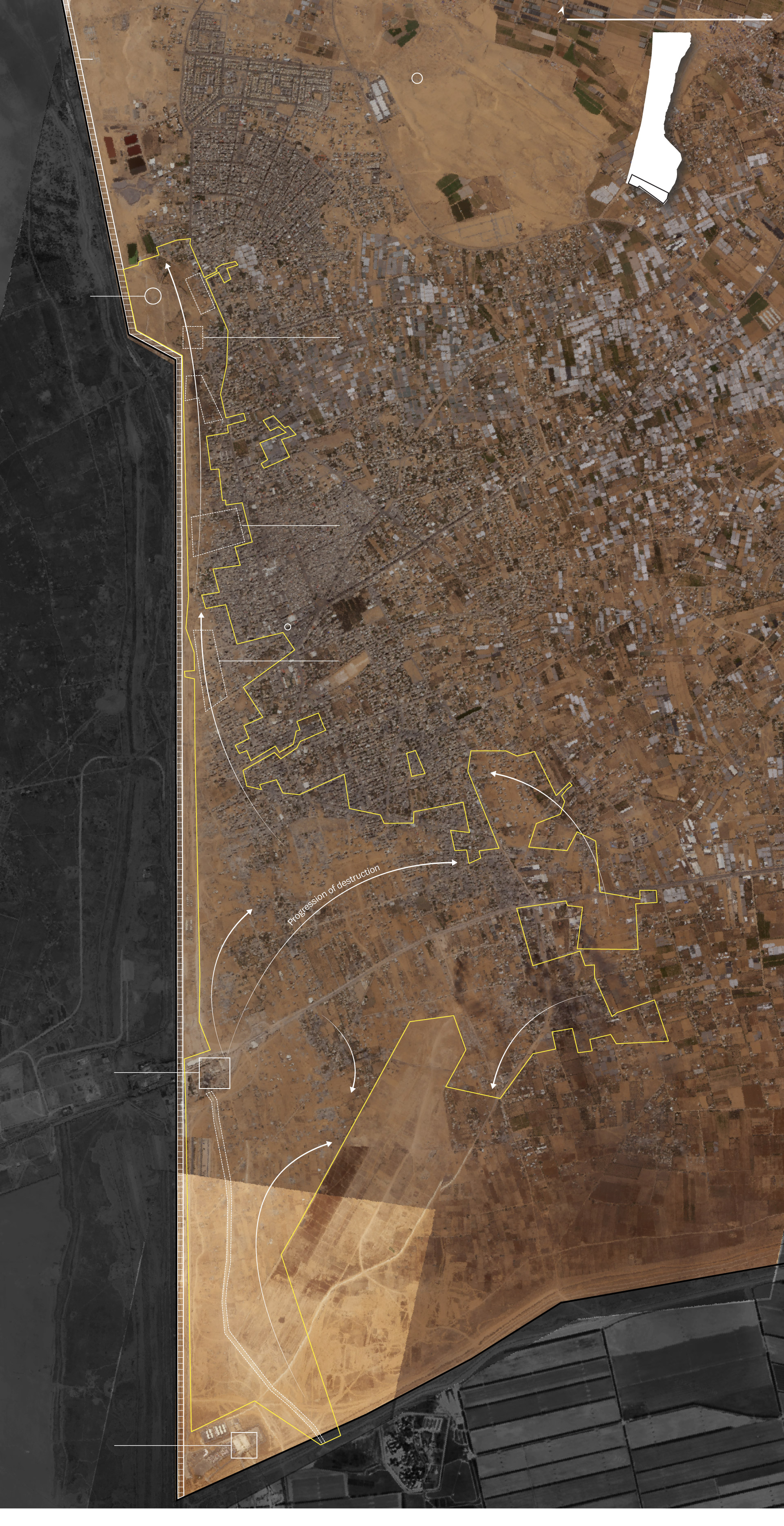
Satellite imagery and videos verified by The Post showed an Israeli offensive steadily encroaching on central Rafah, with military vehicles entering the western neighborhood of Tal al-Sultan, home to many of the civilians who remain. Satellite imagery also points to an Israeli buildup near the Awda area, considered the heart of the city.
Israeli troops have also cleared large swaths of land in eastern Gaza as they have advanced along the Egyptian border in recent weeks, demolishing buildings and plowing over fields, mirroring efforts in other parts of the enclave to create militarized buffer zones.
On Wednesday, the Israel Defense Forces announced it was in full “tactical control” of the Philadelphi Corridor, the nine-mile-long strategic corridor that runs to the Mediterranean Sea along the Gaza-Egypt border — a key military objective aimed at suffocating Hamas smuggling routes.
“Anyone with a rudimentary understanding of military operations can see that a Rafah offensive is underway,” said Bilal Y. Saab, a former Pentagon official and a military analyst with the Chatham House think tank.
It may not meet the criteria of the administration, he said, “but it is no less real or deadly.”
May 26
strike on
tent camp
Israeli military vehicles
Israeli military vehicles
Israeli military vehicles and berms
Visible destruction
May 7 – 29
Source: Planet Labs and Google Earth
May 26
strike on
tent camp
Israeli military vehicles
Israeli military vehicles seen in videos
Israeli military vehicles
Israeli military vehicles and berms
Visible destruction
May 7 – 29
Source: Planet Labs and Google Earth
May 26
strike on
tent camp
Israeli military vehicles seen in videos
Israeli military vehicles
Israeli military vehicles
Israeli military vehicles and berms
Visible destruction
May 7 – 29
Source: Planet Labs and Google Earth
May 26
strike on
tent camp
Israeli military vehicles seen in videos
Israeli military vehicles
Israeli military vehicles
Israeli military vehicles and berms
Visible
destruction
May 7 – 29
Source: Planet Labs and Google Earth
At least 83 people were killed in Rafah between May 24 and May 29, Mohammad al-Mughair, a local civil defense official, said on Wednesday. It’s not clear how many were combatants.
Forty-five of them died Sunday night in an Israeli strike on a makeshift encampment for displaced people in Tal al-Sultan, which unleashed a raging fire and sent shrapnel flying through flimsy tents.
The Israeli military said it was targeting two Hamas commanders, describing the additional deaths as a tragic accident caused by a secondary explosion.
On Friday, Biden described the images from the strike as “terrible.”
“The Palestinian people have endured sheer hell in this war. Too many innocent people have been killed, including thousands of children,” he said. “We all saw the terrible images from a deadly fire in Rafah earlier this week.”
The incident was not an isolated one. On Tuesday, Gaza’s civil defense said at least 21 people were killed by Israeli artillery fire in a tent encampment near the coast. Two ambulance drivers were killed in an Israeli bombing the next day as they raced to treat casualties at the scene of another strike, according to the Palestine Red Crescent Society.
None of the attacks were in Israel’s declared evacuation area. People are now clearing out of central neighborhoods. But there are few options available to families like the one headed by Ahmed, who spoke on the condition that he be identified by his first name out of fear for his safety.
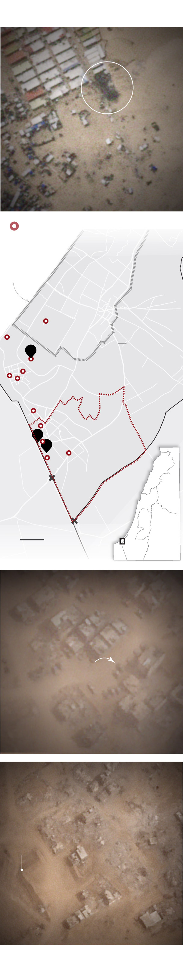
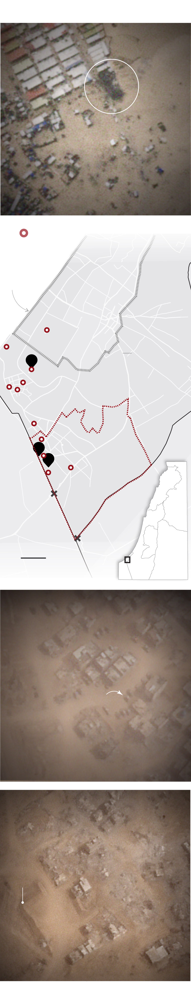
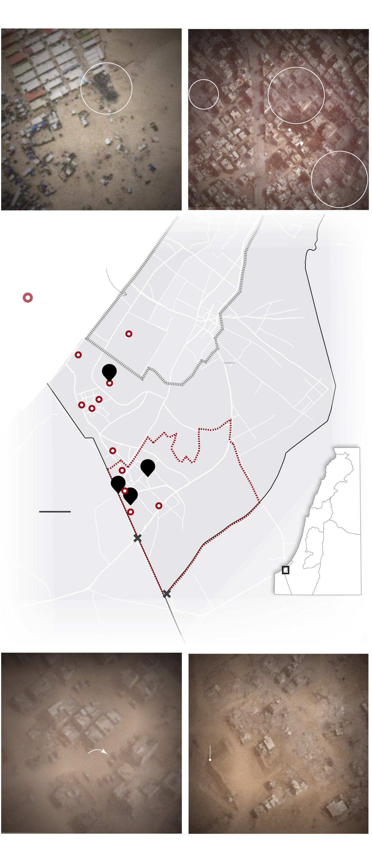
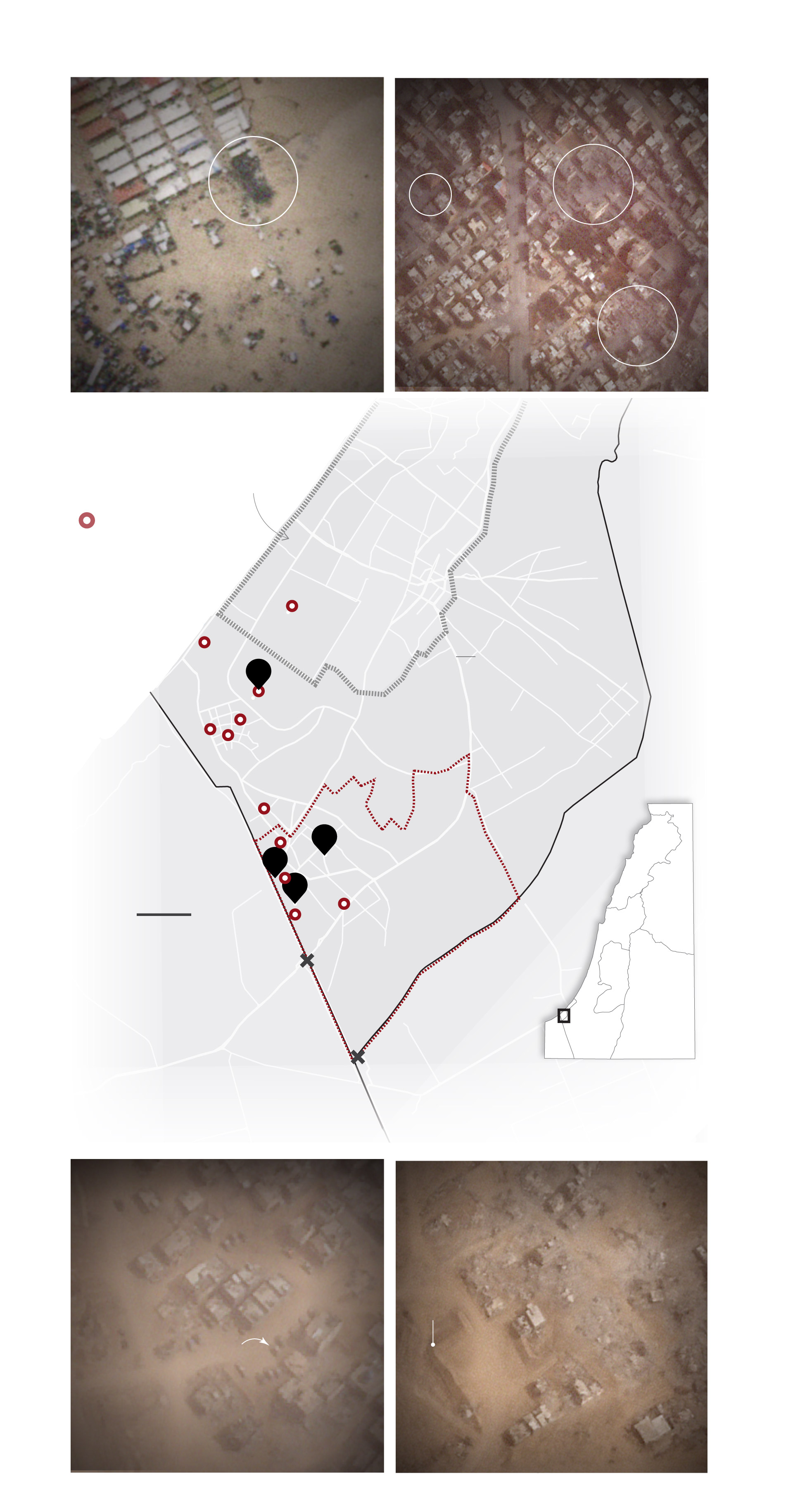
Tracking IDF’s operation in Rafah
Makeshift
accommodation
damaged at
Tal al-Sultan
tent camp
IDF designated
humanitarian
zone
Images source: Satellite images as of May 27, Planet Labs PBC
Tracking IDF’s operation in Rafah
Makeshift
accommodation
damaged at
Tal al-Sultan
tent camp
IDF designated
humanitarian
zone
Images source: Satellite images as of May 27, Planet Labs PBC
Tracking IDF’s operation in Rafah
Makeshift
accommodation
damaged at
Tal al-Sultan
tent camp
IDF designated
humanitarian
zone
Images source: Satellite images as of May 27, Planet Labs PBC
Tracking IDF’s operation in Rafah
Makeshift
accommodation
damaged at
Tal al-Sultan
tent camp
IDF designated
humanitarian
zone
Images source: Satellite images as of May 27, Planet Labs PBC
Ahmed moved with his wife and four children from Juhour al-Deek, in central Gaza, to Tal al-Sultan early in the war. As others evacuated, he decided to stay.
“The area was safe,” Ahmed said. But after another deadly strike in the area Tuesday, the family fled north to Mawasi, a coastal area that Israel has labeled a “humanitarian zone.”
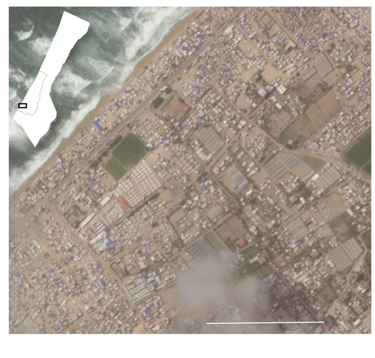
Satellite imagery shows what awaited them there — a seemingly endless stretch of tightly packed tents and other makeshift shelters. There is little access to food, clean water or sanitation.
“People are going crazy,” he said.
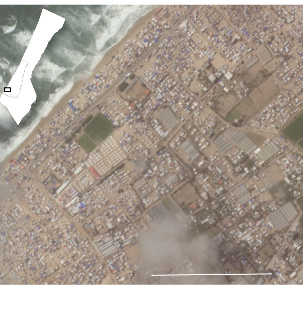
Source: Image as of May 25, Planet Labs PBC
Source: Image as of May 25, Planet Labs PBC
Source: Image as of May 25, Planet Labs PBC
Source: Image as of May 25, Planet Labs PBC
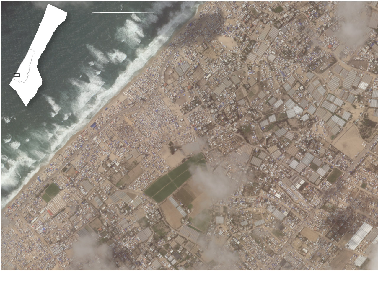
Tanks were first spotted on the edges of Tal al-Sultan early this week. Visuals verified by The Post show military vehicles just south of the neighborhood on Tuesday, aligning with eyewitness accounts.
Residents have reported heavy shelling in the neighborhood since tanks arrived. Ahmed Ghoneim, 40, fled the area Tuesday after what he described as a “frightening, unimaginable night.”
“Every shell felt like it was falling on us,” he said. He spotted the tanks as he left.
The Post reviewed satellite imagery showing what an expert identified as an Israeli military vehicle just off to the side of a street in Tal al-Sultan on Wednesday. A video taken Tuesday shows tracks along the same road that experts said are usually made by heavy military vehicles.
“Things have progressed quite quickly,” said Sam Rose, an official with the U.N. agency for Palestinian refugees. “The tented camps surrounding us are starting to empty out.”
Next to an Emirati field hospital in the Awda area, which residents consider the heart of the city, satellite imagery from Monday shows two clusters totaling more than two dozen vehicles, which appear to be military in nature.
“The fact that they are bunched together suggests this area is secure,” said William Goodhind, an open-source researcher with Contested Ground, a research project that tracks military movements using satellite imagery.
Though the move on Rafah has been “more gradual” than previous offensives in Khan Younis and Gaza City, said Shlomo Brom, a retired Israeli military brigadier general, it is still “a full-sized attack.”
One of the main aims of the Israeli offensive is to gain control of the Philadelphi Corridor along the Egyptian border.
The route “has to be in our hands” in order to demilitarize Gaza when the fighting ends, Prime Minister Benjamin Netanyahu said in December. Israeli officials say Hamas smuggling tunnels still run under the border, a claim vehemently denied by Egypt.
“It is very important when you think about the security and the military situation on the day after,” Brom said, comparing it to the Israeli-controlled Netzarim Corridor, which cuts Gaza in two and has been used to prevent Palestinians from returning north.
When Israeli troops launched their offensive in Rafah on May 6, they made a beeline for the crossing with Egypt, seizing it in an overnight operation and sealing off the most important access point for humanitarian aid.
A new road leading from Israel’s Kerem Shalom border crossing to the Rafah crossing was built by May 18. The road at this stage appears to be a “line of communication from Israeli rear areas to the ‘front,’” said Elliot Chapman, a senior Middle East analyst with security firm Janes.
But in Rafah, as in Netzarim, Israel also appears to be redrawing the map of a strategically sensitive area.
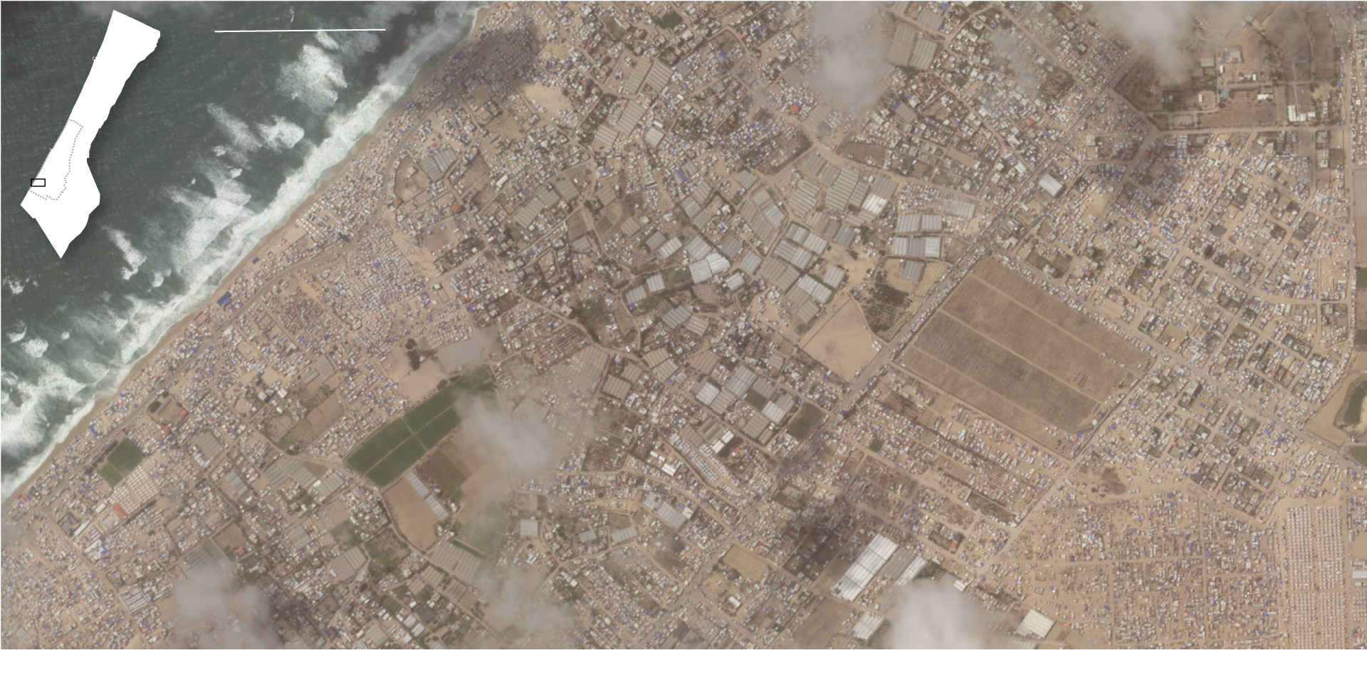
Large swaths of eastern and central Rafah were cleared in the first weeks of Israel’s push, satellite imagery shows, through demolitions and bulldozing, tactics used by the IDF throughout the war to level large parts of Gaza.
About 2,400 buildings in Rafah — or 5 out of every 100 in the city — were damaged between May 4 and May 27, according to an analysis by Jamon Van Den Hoek and Corey Scher, remote-sensing experts who use open-source satellite data to assess destruction across the Gaza Strip.
U.S. officials have warned Israel against any efforts that would reduce the size of Gaza’s territory. But even before the demolitions in Rafah, more than 16 percent of Gaza had been eroded by buffer zones, according to analysis by Adi Ben Nun, a professor in geographic data at the Hebrew University of Jerusalem.
It is unclear how long Israel forces intend to stay on the Egyptian border, but the military will probably want to maintain tunnel detection technology indefinitely, said Amir Avivi, a retired brigadier general in the Israeli military.
Signs of entrenchment are visible from above. Sand berms, used to protect soldiers, are being built on freshly cleared land.
And Israel appears to be planning its next move. Exploratory robots have been sent into Tal al-Sultan alongside tanks in recent days, said Mughair, the Palestinian civil defense official. He expects the city will be stormed soon. Civilians have been blocked from entering; others are pinned down inside.
“We can’t see everything, but everything that we can see tells us that they are not moving in in a major ground operation in population centers in the center of Rafah,” Kirby said Tuesday. “We’re going to watch this hour by hour, day by day.”
Meg Kelly, Heba Farouk Mahfouz, Miriam Berger and Missy Ryan contributed to this report.